Saturday, October 29, 2016

Saint Mathieu, Québec

2,826 miles

Oct 29 – This town is not much more than a country crossroad, but what I can see here gives hints of a long history.  In this part of Québec, every square mile (kilometre) has been parceled out and designated a parish for one saint or another.  Probably there was never a church for each little location, but more likely there were traveling priests.

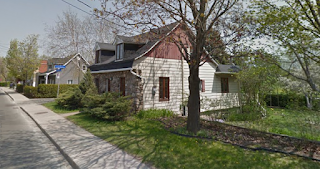
This fieldstone house is quaintly Québécois, with its steep-pitched entry roof and churchy window ornamentation.  

Across the road is another stone-fronted house, this one with that Québécois-style flared roof.  Both houses feature substantial stanchions guarding the driveway entrances.  I guess that these help to mark the edges of the driveways during snowy winters.

well-lit postal center
On another corner at this crossroads is a gravel parking lot with community utility boxes for ready access.  This bank of postal boxes appears to serve 30 households, and it is lit by attractive old-fashioned street lights.  This parking lot may be a significant community gathering spot.


memorial ?
One portion of this corner holds a large rock and cultivated grass and bushes.  A flower bed has been marked off with concrete curbstones, planted with lavender, and carefully tended.  A sign has been erected.  This looks very much like a community memorial.  Is it a war memorial?  Does it commemorate a traffic tragedy at the crossroads?

The real mystery here is:  Why has Google Street Views blurred out the sign?


Leaving Montréal, Quebec

Voie du Fleuve
Oct 29 – When I planned this section of my trip (south now!) toward Vermont, I discovered an extraordinary bike path along the course of the Saint Lawrence River.  Through the river, in fact! 

Montréal seen from the Voie du Fleuve
The Voie du Fleuve (Track of the River) is a bike path built on a long thin artificial island in the Saint Lawrence Seaway.  It stretches 29 km (18 miles) from Île Sainte Hélène, past other islands that constitute the Couvée Islands Bird Sanctuary, past the ferocious Lachine Rapids and the car-accessible Récré-O-Parc, to its scenic and rocky end of the line at a spot in the river that looks like it must have been built for a lighthouse.  I won’t be cycling that entire distance, but Google Maps recommended most of it to go south from Montreal, and it is so scenic and interesting that I must explore!

 Biosphère Environmental Museum
On Île Sainte Hélène (Saint Helen’s Island), the Biosphere environmental museum was originally the exhibition pavilion of the United States for the 1967 World Fair, Expo 67.   It was designed by architect Buckminster Fuller as an example for the world of what Fuller believed to be an ideal building shape.  It is a Class 1, Frequency 16 Icosahedron.  The structure was made of a steel skeleton 250 ft. high (76 meters) in diameter covered with acrylic cells.  The “Minirail” monorail ran through the pavilion to other areas around Expo 67.

In 1976, a fire burned away the building's transparent acrylic bubble, but the hard steel truss structure remained.  

In 1990, Environment Canada turned the structure into an interactive museum showcasing and exploring the water ecosystems of the Great Lakes-Saint Lawrence River regions.  A set of new buildings were built inside the original steel skeleton.  The Biosphère became an environment museum offering interactive activities and presenting exhibitions about environmental issues related to water, climate change, air, ecotechnologies and sustainable development.  I’ve always admired Buckminster Fuller’s geodesic dome idea so I appreciate this museum-in-a-futuristic-bubble.

snow geese,
photo by Jacques Pelletier
The Couvée Islands Bird Sanctuary was originally established as a refuge for ring-billed gulls and other migratory birds.  No one who lives near a port, though, admires gulls much, and few people bother to take pictures of them.  These are more photogenic snow geese.  

Lachine Rapids

The Lachine Rapids in the St. Lawrence River have always been a considerable barrier to maritime traffic through Montréal.  Along 3 miles of the river, because of rocky shelf-like drops underneath, these rapids contain large standing waves, and the water volume and current do not change.  Seasonal variation in the water flow does not change the position of the waves, although it does change their size and shape.  In the past, travelers and merchants had to portage 8 or 9 miles from Montreal's port to the village of Lachine where they could resume their trip by boat.  It was usually more convenient to ship goods by rail to Montreal, where they could be loaded at the city's port. Montreal remains a major rail hub and one of Canada's largest ports for that reason.

The original French name for the village and the rapids was La Chine, in hopes that this was the Northwest Passage that would lead Europeans to China.
In 1825 the Lachine Canal was built right through the island of Montreal, and deepened later, to enable ships to navigate around the rapids in the main river.  

Lachine Canal in winter
After the growth and decline of industrial production, the canal was partially filled in to develop the Métro subway system and the Underground City.   In 2002, parts of the Lachine Canal were reopened as a pleasure boating area, despite environmental concerns about heavy industrial contamination of its bottom. An environmental reclamation project continues to clean up old oil spills.  The banks of the canal offer bicycling and rollerblading.  Parks Canada offers guided tours of the canal by foot, bicycle, and boat during the summer months.

A pilot boat guides
the former Canadian Navy DDH Fraser
upriver through the South Shore Canal. 
The South Shore Canal, with the Saint-Lambert and Côte Sainte-Catherine locks, now enables modern ships to avoid the unpassable rapids.   The Voie du Fleuve (or Voie de la Voie Maritime) is the maintenance access road built across a series of artificial islands that create the edge of the canal, which has now become also a bicycle path.


Saturday, October 22, 2016

Montréal, Québec

La Ville Souterraine
2,811 miles

Oct 22 – Montréal is the largest, most glorious city that I will have passed through on my transcontinental journey.  I cannot possibly do it justice in a single blogpost.  I found 2 interesting curiosities to explore in the heart of downtown Montréal.

La Ville Souterraine (The Underground City) caught my attention because Seattle also has an underground portion of the city.

The Seattle Underground is a network of underground passageways and basements downtown that was at ground level in the mid-19th century.  The original Pioneer Square sector had been built mostly on filled-in tidelands which often flooded, and Seattle's first buildings were wooden.  In 1889, the Great Seattle Fire destroyed 31 blocks.

Seattle Underground shop fronts
Instead of rebuilding the city as it was before, the city leaders decided that all new buildings must be made of stone or brick and that the streets should be regraded from one to two stories (12-30 feet) higher than the original street grade. (The new street level also assisted in ensuring that gravity-assisted flush toilets that funneled into Elliott Bay did not back up at high tide.)

Underground Tour guide showing sidewalk skylights,
by Seattle Times artist Gabriel Campanario
Once the new sidewalks were complete, building owners moved their businesses to the new ground floor, although merchants carried on business in the lowest floors of buildings that survived the fire, and pedestrians continued to use the underground sidewalks lit by glass prisms embedded in the grade-level sidewalk above.

In 1907, two years before the 1909 World Fair in Seattle (Alaska-Yukon-Pacific Exposition), the city condemned the Underground for fear of rats and bubonic plague. The basements were left to deteriorate or were used as storage. Some became illegal flophouses for the homeless, gambling halls, speakeasies, and opium dens.

After the streets were elevated, the original ground-level spaces fell into disuse, but a small portion of them were restored and made accessible in the late 20th century, and the guided tours of the Seattle Underground have become a popular tourist attraction.


La Ville Souterraine map
In Montreal, La Ville Souterraine (The Underground City) is a series of interconnected office towers, hotels, shopping centers, residential and commercial complexes, convention halls, universities and performing arts venues that form the heart of Montreal's central business district.  Although the complex was started in 1962 to cover an unsightly pit of railway tracks north of the Central Station, and vast commercial sectors are located entirely underground, the Underground City has become more of an indoor city (ville intérieure) than a truly subterranean place.  

The underground city is promoted as an important tourist attraction by most Montreal travel guidebooks, and it is an impressive urban planning achievement.  For most Montrealers, however, it tends to be known more as a large mall complex linking Metro stations — they may not even know they are in it.  The area is usually just called “Downtown Montreal”, or one of the shopping malls is mentioned as a reference point.


The term "underground city" is not used by local Montreal residents.  The official name “RÉSO” is a homophone of the French word réseau, or network, so the name refers to the underground connections between the buildings, in addition to the network's complete integration with the city's entirely subterranean rapid transit system, the Métro.  The "O" at the end of the word is the logo of the Métro subway system.

Though most of the connecting tunnels pass underground, some passageways and all the principal access points are located at ground level and it even has a few skywalks.  The network is particularly useful during Montreal's long winters, during which time well over half a million citizens are estimated to use it every day. The network is largely climate-controlled and well-lit.  Combined, there are 32 kilometers' worth of tunnels over twelve square kilometres of the most densely populated part of Montreal.

In total, there are more than 120 exterior access points to the network, not including the sixty or so Métro stations located outside the official limits of the Réso, some of which have their own smaller tunnel networks. Some of the city's larger institutions, namely McGill University, the Montreal Museum of Fine Arts, Concordia University and the Université de Montréal, also have campus tunnel networks separate from the Underground City.

In fact, many Canadian cities have some kind of tunnel or skywalk system downtown to help people avoid the weather. 

Underground City atrium with ice rink & skylights
The RÉSO is possibly the most famous underground city in the world, currently used by more people than any other (nearly 500,000 people per day). It is also the largest underground complex in the world. It stretches for 32 kilometers (20 miles) and covers 4 million square meters. According to official statistics, its corridors link up with 10 metro stations, 2 bus terminals, 1,200 offices, about 2,000 stores including 2 department stores, approximately 1,600 housing units, 200 restaurants, 40 banks, 40 movie theatres and other entertainment venues, 7 hotels, 4 universities, the Place des Arts, a cathedral, the Bell Centre (home arena of the Montreal Canadiens hockey team), and 3 exhibition halls, including the Olympic Centre.  What a way to enjoy a Montreal winter!

Vieux-Port de Montréal
The area now known as the Old Port of Montreal stretches for over two kilometers along the St. Lawrence River.  It was used as a trading post by French fur traders as early as 1611.  In 1976, the city's port activities were moved east to the present Port of Montreal in the borough of Mercier-Hochelaga-Maisonneuve.
The Old Port was redeveloped in the early 1990s, into a recreational and historical area that draws six million tourists annually.  Its riverfront location offers a wide variety of activities, including walking, cycling, and rollerblading, and rentals of quadricycles, pedalos and Segways.   The area also includes the Montréal Science Centre, with an IMAX Theatre, and the iconic Montreal Clock Tower.  

What I see as I arrive by virtual bike is a pirate ship aground with rigging that extends far beyond the ship.  

This is an obstacle course designed for children to climb around on. Voile en Voile Pirate Ship Adventure Park features two ships linked by a series of high rope adventures. 

The ships themselves have 5 different aerial courses, 2 ziplines, and over 61 different activities including: climbing walls, labyrinths, swings and inflatable playground structures.

SOS Labyrinthe map
Also in the former port area is the SOS Labyrinthe, which claims to be the largest indoor maze in the world.  It was created within a 100-year-old dockside “hangar” in the 1970s.  (I was unable to find out why it is called “SOS”, although the Voile en Voile name for the Pirate Ship Adventure Park means "Sail on Sail", and SOS could be an abbreviated and Anglicized version of that.)  
SOS Labyrinthe changeable megamaze
The maze is built with plastic sheets tied onto pipes so that the design can be changed from time to time, and sturdier structures are erected for specific purposes.  Historic items are hidden within the megamaze for visitors to seek & find.  On Thursday and Friday nights, the lights are turned off so that visitors can find their way by touch and by flashlight.  This might be another fun indoor activity for Montrealers, but it must be very cold inside.  The megamaze is closed from November until May.

info: Wikipedia. com

 images:  Google Images

Monday, October 17, 2016

Laval, Quebec

2,796 miles

Oct 17 – As I approach the metropolis of Montréal, I learn that it is built on a cluster of islands at a place where several rivers flow together to create the great Fleuve Saint-Laurent (Saint Lawrence River).    

Laval occupies all of Île Jésus (Jesus Island) as well as a few islands in the the Rivière des Prairies, the Îles Laval (Laval Islands).

First, I cross the Rivière des Mille Îles (“River of a Thousand Islands”).  Is this where Thousand Island salad dressing was created?  Well, yes!  

Amid several folktales about the exact origin, most agree that this is the region where the salad dressing and condiment originated.*


The first European settlers were Jesuit priests who were granted a seigneury here in 1636.  Laval was named after François de Montmorency-Laval, the first Roman Catholic Bishop of Quebec.

Carrefour Laval (Laval Crossroads) Shopping Mall
Designed to resemble a French city park.
From its agricultural roots, Laval began to grow throughout the 20th century, based on its attraction for Montréal vacationers.  As the city grew and transportation improved, Laval’s proximity to Montréal turned it into an attractive suburb.
To deal with problems caused by urbanization, small communities were amalgamated into larger ones.  In 1965, the Quebec government decided to amalgamate the whole island into a single city of Laval in 1965, even though there was local resistance.

According to the 2011 Census of Canada, the population of Laval was then about 400,000.  At that time, French was the sole mother tongue of only 61% of the population, and the next most common mother tongues were English (7%) and Arabic (6%).  This does not seem as strongly francophone as I had seen in the rural areas, and not as I had expected.  In community life, I wonder how many of these English- and Arab-speaking residents use French, or do they rely on English?  This year’s census should provide interesting results.

Laval has been the scene of political struggles between the Québec separatists (Parti Québécois) and the federalist Québec Liberal Party.  The federalists seem to be in power now, and likely to gain momentum with immigrants continuing to arrive.

Université  Laval
a fortress of learning
I see the influence of old Québec in the modern architecture.  Many public buildings are made of gray fieldstone, and many homes use the stone for a facing, at least.  This building at the Université Laval looks like a fortress. 

The original French “habitants” (peasant settlers) were largely from Normandy, and they brought along their own ideas of home building.  As a practical matter, their steep roofs shed snow efficiently.  
When they created porches, the roofline developed a pretty flair at the edge, as seen on these houses in Laval-des-Rapides.

Pont Viau across the Rivière des Prairies
Here is the beautiful bridge that will take me into the city of Montréal proper.


*  The salad dressing also became the “Special Sauce” in many fast food restaurants, since it contains the condiment basics of catsup, mustard, pickles, & onions.

info:  Wikipedia.com
images:  Google Images 

Wednesday, October 12, 2016

Mirabel, Quebec

2,781 miles

Oct 12 – Approaching Montréal and its islands, I am now in one of the outer (“off-island”) suburbs, Mirabel.

Although the municipality was administratively created by mergers of small communities in 1973, the name had been common in the area for a century before that.   A Scottish officer of the Canadian Pacific Railway had bought some land and and created a name for his new farm.  Since his two daughters were named Myriam and Isabel, he chose the name Mirabel for his farm.  The combination is a Spanish spelling for a personal name, meaning “wondrous beauty”.  Later, in 1886, the federal government authorized the CPR to carry mail, and the man opened a post office nearby using that name.

Montreal-Mirabel International Airport
(abandoned)
In 1975, the Montréal-Mirabel International Airport was built to be a major aviation hub surrounded by industrial parks, but it was too far from downtown Montréal to function well.  Mirabel Airport declined, and in 2004 the airport closed to all passenger traffic.   After the passenger terminal closed, it was used for filming on the Tom Hanks film The Terminal and for other TV shows and movies.  There were even ideas about turning the airport into a theme park, but those plans fell through and the passenger terminal was demolished in 2014.


Mirabel has found other sources of prosperity, and it has a beautiful park system. This park named Bois de Belle-Rivière (Woods on the Beautiful Island”) belongs to the city, and residents of Mirabel may enjoy it for free.  Each non-resident pays an entry fee – including dogs.
PRICES
Adults: $ 6
Children: $ 2 (6 to 16)
Dog: $ 1

The motto for the park is: “Explore Nature in Four Seasons!”  It is open year round, but after Labour Day* in September, specific summer activities are closed: a beach, paddling, and fishing ponds.  In all seasons the walking paths, picnic shelters, rest areas are open, plus horseback riding, for a fee.  

Special events are organized throughout the year for bird watching and a treasure hunt rally using GPS. 

Take a look at this incredible entrance to a labyrinth!

winter ice path


In the winter, the park offers:  a forest ice path, ice rink, a cross-country ski beginner track, a snowslide for tubing (depending on temperature), and snowshoeing trails (depending on snowfall).  Special events this winter include  a  skating night with torches and Snow Fest.

This seems like a very active park, and it’s great to have such a woodsy park so near the city.


info:  Wikipeida.com
images: Google Images 


* Canadians celebrate Labour Day on the same day Americans celebrate Labor Day.  But Québécois Canadiens celebrate Fête du travail.  Ooh!  I’m writing franglais!

Thursday, October 6, 2016

Rivière du Nord, Quebec

Rivière du Nord
2,766 miles

Oct 6 – I’m crossing the Rivière du Nord (North River) on a boring flat highway through flat farmland, at a calm place in the river.  The river got its name simply because it flows into the north side of the Ottawa River.

The Rivière du Nord features exciting waterfalls and rapids, so it attracts kayakers and sightseers, but that is farther upstream and farther north, in St. Jerome at the Parc Régional de la Rivière du Nord.

Just past this bridge I find a road called Chemin de l’Île aux Chats.  The Road to the Island of the Cats!  Surely this is worth investigating!

South of here, visible only by map, the Rivière du Nord flows around an island called the Island of the Cats.  How on earth is there an island in rural Quebec that became inhabited primarily by cats?

Chats Falls,
by Philip John Bainbrigge
It turns out that a few places in Quebec are named for cats! 
Chats Falls (Anglicized from French “Chute des Chats”) was a series of waterfalls on the Ottawa River near Quyon.   

Another Île aux Chats is located closer to Montreal on the Prairies River.

Erie warrior, 19th century


One theory for the derivation of this intriguing name is that people of an Erie tribe were living in the vicinity, who were often mentioned in historical writings of the Jesuit missionaries, and the word "Erie" in the local Iroquois language means cougar.

Another legend explains that early explorers found many raccoons on these islands, which were then called wild cats (“chats sauvages”). 


The rapids at Chats Falls are now covered by hydroelectric power dams.  The reservoir is named Lac des Chats (“Lake of Cats”), but translated as Chats Lake.

Île aux Chats near Montreal is now a nature preserve owned by the city.

This Île aux Chats on the Rivière du Nord is a residential island among farm fields.  It appears to be a bedroom community for Montreal exurban commuters or for workers at the hydroelectric power dam on the Ottawa River at Carillon.

I continue now into the northwestern suburbs of Montreal.

info:  Wikipedia.com
images:  Google Images 


Saturday, October 1, 2016

Calumet, Quebec

2,751 miles

Calumet Falls, 1878
Oct 1 – Calumet is a borough of the municipality of Grenville-sur-la-Rouge, Quebec.  Until 2002, it was an independent village, but in this time of population decline, its administration was merged with the township of Grenville.  Each of the two communities became boroughs of the new municipality, and it took the name Grenville-sur-la-Rouge. 

But Calumet is not on the Rouge River; it’s on the Calumet River, which is a completely separate tributary to the Ottawa River.  Just upriver from the highway bridge is a scenic waterfall, but it is located on private land and no one has posted free photos of it.  This is an 1878 view of it, courtesy of the McCord Museum of Canadian History in Montreal.  The Quebecois method of creating bilingual titles is interesting to me.  The French name is Musée McCord, the English is McCord Museum, so the combined form for this is Musée McCord Museum.


In researching this town, I discovered many places named Calumet.  In the northern Midwest of the U.S., there are 17 places with this name.  Several American ships have borne this name.  Two colleges are named Calumet, one in the Illinois and one in Ontario.  And Quebec itself holds three places with the name, and all of them on the Ottawa River:
  • ·        this borough on the Calumet River,
  • ·        Pointe-Calumet, on a wider part of the Ottawa where the the Rivière des Mille Îles (River of a Thousand Islands) and the Prairies River flow together to become Lac des Deux Montagnes (Lake of the Two Mountains), and
  • ·        L'Île-du-Grand-Calumet, a municipality and a large island in the Ottawa River, located in the Outaouais region, northwest of Shawville


I wondered why this name was so popular in this region from Pennsylvania to Quebec to Iowa.  What early explorer or Native great chief was so honored in these many ways? 

It all made sense when I learned that a calumet is a French-derived word for a peace pipe.  The places so-named are commemorations of ceremonial attempts to build friendship between the First Peoples and the European immigrants.  

County Seal of Calumet County, Wisconsin
This reminds me of remarks from Bob Goulais of the Nipissing people in Yellek,Ontario.  He commented on the sad contrast between the traditional sacred ceremonial use of tobacco, “in prayer and when we need to ask things of each other and the Spirit World” and the misuse and overuse of tobacco as an addictive and carcinogenic commonplace palliative.  

Rue Principale (Main Street)
The main street of Calumet (Rue Principale) is surprisingly crowded by buildings, although there is much empty land behind them.  The original village seems to have been designed like a medieval European village, with houses right on the edge of the road.  More recent buildings are set back a bit.

Calumet has two streets, the main street and the Rue des Érables (Maple Street) where the old train station sits, boarded up in a grassy yard.


donation box?

This structure next to the Église Saint-Ludger Catholic Church appears to be a donation box for the poor.  Perhaps it is also the place for poor people to go get donated items.


Strangely, the English-only sign identifying the Holy Trinity Anglican Church has been blurred out by Google.  Have the Anglican Quebecois been flouting the language laws?  Was Google asked to blur this sign?  This seems like draconian regulation, but I can’t think of any other explanation.


info:  Wikipedia.com
images: Google Images, Google Street Views
Musée McCord Museum:  http://www.mccord-museum.qc.ca/en/