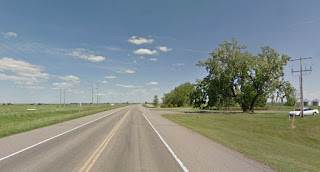
Dec 11 – I was really looking forward to seeing images of some beautiful natural
springs with purple coloration in the water or the surrounding rocks. I found no hint of any springs or any
justification for this enticing name.
Purple Springs is a hamlet (less than 300 people), and the most
interesting picture I found was this Google street view of a large old tree near
what was an old farmhouse, and a parked (junked?) car in the grass.
But this image led me to another blogger and virtual traveler,
Andrew Dunn, of Vancouver, British Columbia.
He bikes 7 km to & from work, but wanted to turn that commute into a
virtual ride across Canada to St. Johns, Newfoundland.
That’s 8,000 km (4,970 miles) – way farther
than my own transcontinental ambitions!
And Andrew needs to deal with the real-life weather & traffic of
Vancouver in all seasons. All of Andrew’s
images are from Google Street Views, so they show literally what you could see
from the road.
Virtual Trans-Canada Project: https://virtualbikeride.wordpress.com/about/


If you want to see where the name Purple Springs came from, you need to take the cross road just west of the hamlet and travel about 2 miles due south where you will come to a small valley. The area has changed a lot since the 50s and 60s when I lived there, but there is still somewhat of a slough in the bottom of the valley. The crocuses blooming on the sides of the slough were reflected in the water. The slough was spring fed. Thus the name Purple Springs. The crocuses were gone by the time I lived there. Had some fair skiing on the coulee hills. There used to be sheep pastured on the area. There was an old sheep dip just west of the road on the north side of the valley. I think the last time the road was built up, the dip was destroyed.
ReplyDeleteThank you for painting such a vivid picture of this place. What a sweet oasis that crocus-strewn spring must have been!
ReplyDelete