2,142 miles
 |
| M-28 east of Newberry |
This road is
looking as straight & flat & featureless as the Seney Stretch. So I decided to find out more about the
highway itself. Michigan Route 28 (M-28)
extends across the length of the Upper Peninsula, passing through forested
woodlands, bog swamps, towns, & along the Lake Superior shoreline. The roadway goes through the Ottawa National
Forest and both units of the Hiawatha National Forest, and crosses several
historic bridges. Its main purpose
appears to be truck transportation of goods from cities at one of the peninsula
to cities at the other end. The people
who live here have been trying to use it to bring paying visitors to the “attractions”
they have created.
M-28 is an
original trunkline designation, dating to the 1919 formation of the state's
trunkline system. The original highway started in the western part of the Upper
Peninsula and was expanded eastward to the Sault Ste. Marie area in the late
1920s. Other changes along the routing
have led to the creation of three different business loops at various times,
but only one still exists, around Marquette. The Marquette County Road Commission
has proposed a re-route of M-28 even farther away from Marquette, but the state
commission has not accepted this idea. Apparently,
the through-traffic of trucks should be kept far out of town.
 |
| Old Flowing Well rest area |
Along M-28, the
Michigan Department of Transportation has established several roadside parks
and rest areas, some of which I’ve visited (virtually). The first was in Ontonagon County at Trout
Creek. I didn’t know yet that it was
part of a system of roadside parks. In
Baraga County, I saw a park with a picnic area and a footbridge across Tioga
Creek, with a view of a charming small waterfall. In
Three Lakes County, I passed by a scenic turnout and a roadside park overlook at
Lake Michigamme. In Au Train, I
virtually visited the roadside park that includes Scott Falls. I missed a few more around McMillan west of
Newberry, but I am delighted by this idea.
Scenic public rest areas are a wonderful feature to welcome visitors
along a through-route.

In Soo
Junction, just a couple of miles off the highway, is a tourist business using an
old narrow 24-inch gauge mining trolley & tracks to provide scenic
tours. Ride the train 5½ miles through
the habitat of bear, deer, and birds to a private boat landing on the
Tahquamenon River.

Board an old
riverboat that takes passengers on a 21-mile cruise along the river to the
rapids a half-mile above the Upper Tahquamenon Falls. During the cruise, enjoy a sandwich or
beverage from the on-board cafeteria, then take a nature hike (5/8 mile)
through the forest to view the waterfall.
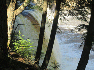 |
| Tahquamenon Falls from trail above |
Passengers then board the boat for the return
trip to the train and the ride back to Soo Junction. Quite a day’s trip! It claims to be the only tour to the falls,
despite the one offered from McMillan by dogsled.
highway
image: Google Street Views
info: Wikipedia.com
tour info
& images: http://www.exploringthenorth.com/toonerville/trolley.html
No comments:
Post a Comment