May 9 – Here, a little ways past the town of Iron Bridge, my highway route runs right next to the Mississagi River. There’s nothing else in sight for miles, so I
decided to contemplate the river itself.
 |
A Snowy Owl in Flight,
by David Hemmings |
The Mississagi River meanders from lake to lake in
soggy Ontario. It begins in a small
unnamed lake in Sudbury District and flows into White Owl Lake, from which it
flows into Mississagi Lake. This must involve a lot of meltwater in the springtime.
The river then turns south and
heads to Kettle Lake, the furthest point east it reaches, before continuing
south and entering Mississagi River Provincial Park at Upper Bark Lake.
 |
| zigzag route to Hellgate Rapids |
The river continues south, enters the large "L"-shaped Bark Lake, then heads west through Hellgate Rapids.
 |
| Hellgate Rapids |
The
Mississagi takes in a tributary, the Abinette River, then splits into two
channels to form an island, recombines, and enters the large Rocky Island Lake,
where another tributary, the Cypress River, enters. It then flows into Aubrey Lake, where the
Wenebegon Rivers join it.
 |
| Aubrey Falls - spectacular beauty! |
Even though much of the
water is funneled into a power station, some continues to flow over Aubrey
Falls.
The
Mississagi turns south and a right tributary Aubinadong River enters, followed
by two left tributaries, the Sharpsand River and the Rapid River in quick
succession, and further on, another left tributary, Snowshoe Creek from
Wakomata Lake.
 |
| Red Rock Generating Station |
Then it reaches Tunnel
Lake, created by dams for two generating stations. The river flows southeast where the left
tributary Little White River enters, and continues to Red Rock Lake, another
reservoir lake created for a generating station, over the Shino Rapids, takes
in the right tributary Bolton River, then reaches Lake Huron.
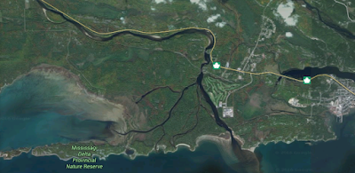 |
| bird's foot delta of the Mississagi River |
The river's delta is a "bird's
foot" delta, a type not commonly found on the Great Lakes. (The Mississippi River in Louisiana has a
bird's foot delta.)
The Ojibwa
people used the river to travel between the forests of the interior and Lake
Huron. In 1799, the North West Company built a fur trading post at the mouth of
the river. This post was closed in 1900.
 |
| logs ready to float to the sawmill |
During the second half of the 19th
century, the river was used to transport logs to sawmills at Blind River. Nowadays, the back country has become more generally accessible by the use of float planes to fly hunters & campers to the mountain lakes.
This is a relatively short river with a lot of variety within its meandering course.
info:
Wikipedia.com
maps: Google
Maps
Red Rock
Station:
https://brianlangis.wordpress.com/


 The river then turns south and
heads to Kettle Lake, the furthest point east it reaches, before continuing
south and entering Mississagi River Provincial Park at Upper Bark Lake.
The river then turns south and
heads to Kettle Lake, the furthest point east it reaches, before continuing
south and entering Mississagi River Provincial Park at Upper Bark Lake.


No comments:
Post a Comment