2,303 miles
May 12 - Across the
road from my stopping point today I “see” on Google Street View an industrial
building behind a gate. I’m amused to
see rusty railroad tracks curving out of this compound toward the highway, and
then not crossing it but simply fading away underneath.
I turn toward the other
side of the road, and see the tracks fading away in the other direction. On Earth View, I can see that it connects to
the main railroad tracks. Apparently,
this business used to ship something by rail, but no longer does.
Looking
again at the front of the compound for clues to its business, I can see huge
metal towers, and surmise that it is an electric power transfer station.
Curious about where this power is coming
from, I look at Google Earth View to follow the shorn landscape under the
towers.
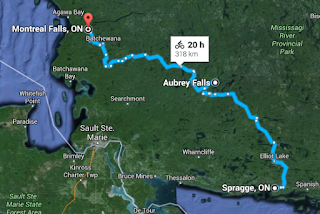
The line
comes all the way from the Montreal Falls power station on the Montreal
River! This is nowhere near the
well-known city of Montréal on the island of Montréal in Quebec. Nor is it the Montreal River on the U.P. that
flows into Lake Superior at the Wisconsin-Michigan border. This is another Montreal River, Lake, and
Falls that flow into Lake Superior north of Sault St. Marie.
Why is electric
power being sent all that way when the local Mississagi River contains several dams
& hydroelectric power stations? What
about the Aubrey Falls Generating Station, about halfway between Spragge & the
lake Superior Montreal Falls? What about
the George W Rayner Generating Station at Tunnel Lake? What about the Wells Generating Station above
Iron Bridge? Well, OK, there is also a
connection to the station at Tunnel Lake.
And a line going eastward that I have not investigated. Hmm.
This is looking less like one-way lines of power from source to users,
and more like the “power grid” that I've been hearing about but hadn’t
understood before.
There’s something new to ponder every day.


No comments:
Post a Comment